Day 10 Montrose to Lake City to Sargents to Salida to Howard 223 Miles 11 Hours
I woke up at 3:30 am which is apparantly my habit now. Usually I turn on a podcast on my phone and fade in and out of sleep until 5:00 am or so. Not this time. I knew I wasn’t going back to sleep at all. I laid there til 4 am and then started packing things up.
The Owl Creek Pass closure was a real bummer, but Johny Pow / Mission Control had helped me plan how to get down to Lake City without having to detour four hours north because of a bridge being out. I feel like I should have run up Cinnamon to see what it was like. I keep checking the TAT Facebook page to see if anyone has gone through the passes this past week and I haven’t seen anything. Although there was one video of a guy doing Ophir kind of recently, and honestly - I wouldn’t have wanted to be up there in the conditions I saw. He said it was easy though. I thought Ophir was the scariest thing in the world - and we did it in perfect conditions. I’ll likely never do Ophir again - (cut to.)But I made the decision and it’s too late now. It was 60 degrees already in Montrose so I put on some shorts under my protective gear. I was on the road by 5 am. Usually I won’t ride in the dark, but the sun was coming up soon - might as well get a couple of miles in. I’m awake. What else am I going to do?
I was expecting Hwy 50 to be a full on four lane highway. What was I thinking? It was two lane with some passing lanes every now and then and it was gorgeous. Riding at sunrise is a good idea. I had planned to stop in Cimmaron for some fuel but they weren’t open and didn’t have 24 hour pumps. So I checked the axel nut for fun instead, added my sticker to the collage of stickers on the pumps, and moved on.
The sunrise coming up over the resevoir was gorgeous.
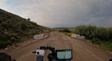
I turned right on to Blue Mesa which was the road Johnny Pow found that was to take me south to Lake City. The sign said road closed. Now you have to be selective about what a sign says and what a sign means and what is true. You also have to weigh the pros and cons. I have plenty of fuel to get to Lake City as long as there are no surprises. And going down a remote road that says it’s closed can get you into trouble. You might go 30 miles and then find out it really is closed and there’s no way through. You might hit a locked gate. You might run into a road work crew. So my choice was - do that four hour trip north and around, or roll the dice and see what happens. I chose to see what happens. We’ll find out later if that was a good choice or not.
The longer you go down a road like this the more anxious you feel because every mile is a mile you’ll have to backtrack if things don’t work out and that means take the fuel you’ve already spent and times it by two. I passed a sign saying that it was Ute land. I went through a gorgeous canyon at the start and then into some wide open spaces. It was something to see.
The anxiety got to me and I turned around. Then I turned around again and kept going. And then I’d gone far enough where turning around would really suck.
There was a road crew guy sleeping in his truck before the start of his work day. I tapped the horn as politely as I could to wake him up. I walked up and he rolled down his window and I apologized for waking and bothering him, but did he know if this road went through. He said he thought it went to Gunnison. “There are gates but the ranchers keep cutting them to detour around the bridge closure.” Okay. Gates are a negative. Open gates are a positive. The only way to test the open-ness or closed-ness is to go to the gate. Gunnnison wouldn’t be great, but at least the road goes through. And the track I was looking at definitely went to Lake City. I kept moving.
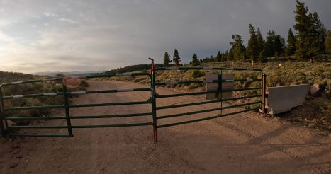
I was a little uncomfortable with possibly being on Ute land that I wasn’t supposed to be on. But this track came from a Colorado BDR route, and they aren’t supposed to ever put you on private roads. So I just continued on while feeling a little quesy about it. I came to the first gate that was wide open.
Then I saw a car coming from the other direction. I stopped and held out my hand in a gesture asking them to stop. They did and he rolled down his window. I asked him if this road went through to Lake City. He said it did, but he also said, “How did you get this far?” I told him that the white gate was open. He was super friendly and not mad at me at all for being there which put me at ease. He said, “You’re lucky you got this far - that gate is usually locked. And I just left my gate unlocked when I left which I don’t usually do. So you keep going and DO NOT leave this road and it’s okay for you to go through my gate.” I have no idea what he meant by his gate. He said I was having a very lucky day because usually they’re locked and people just have to turn around and go all the way back out, and then do the standard detour which in addition to being way longer - he said they only bring you through on a schedule that is every 45 to 60 minutes. A pilot vehicle leads you through and then turns around and leads the people going the other way through.I don’t understand if this is a public or private road. I don’t understand how BDR riders get through which they must - so are the gates closed because of the detour around the bridge? I just don’t get it. But now I have permission from someone, so that makes me feel better. I did my profuse thanking ritual and we said goodbye.
I got to the gate and it looked locked as hell to me. For a second I thought he’d played a prank on me. But it wasn’t and he didn’t. That would have been a good one.
I went through. And then up ahead a few miles later was a white pickup who pulled over and stopped to let me pass. I stopped and he rolled down his window. I don’t want to step into a politically correct mindfield here by describing a person’s racial characteristics, but the guy in the truck was an incredibly handsome older Native American guy, probably 65, with deep creases in his face, gray hair with streaks of darkness underneath that was pulled back into a braid that went down his back, a bracelet made of copper strands that were woven together on his wrist, and an accent that made me wish for another go at life in a different culture than the one I’ve had the first time around. I liked this guy very much instantly. I would happily sit in a lecture room and listen to him speak about whatever he wanted to speak about from a podium for as long as he wanted to talk. Change the location to a porch way out here and I’d listen for double that time. He told me that I was on the right track, that across the bridge at the bottom of the mountain I could go left to Gunnison or right to Lake City. He didn’t seem upset at all that I was there. Here’s another stranger I’d sure like to have breakfast with. Thank you ritual performed and I drove off wondering if he’d made the bracelet himself and if I could pull something like that off. The result of that wondering was that I certainly could not. I couldn’t even pull off my “extra” glasses.
Speaking of political correctness - I was thinking today that I grew up in a time when My Sharona was not even given a second glance. Listen to that song and let me know if those pedo lyrics would fly today. It is a catchy tune though - you have to admit.
I used up some luck not being turned back by those gates. But aside from the constant “please let this go through” thoughts, let me remind you that this was all beautful country.
The bridge and right to Lake City!
Now I would never ever in a million years wake someone up like I did the construction guy in my normal life. It’s just so rude. I would never put up my hand to stop a car from going by. I just don’t usually make contact with strangers. But when you’re out in the middle of nowhere with a real need for information - you do what you have to do. And every interaction is usually so pleasant and it’s nourishing to see that people’s first instinct is to help out. That’s just good knowledge to have in the old back pocket.
I fueled up in Lake City and found a great little coffee shop. It was only 7:30 am, and I felt like I’d ridden for a day already.
I was finally back on Sam’s Trans America Trail for the first time since 2021 and I could feel it happen. I was ready to re-ignite my old relationship with Sam and the route he’s poured his life into. I trust Sam implicitly. He’s an artist. His route is a masterpiece.
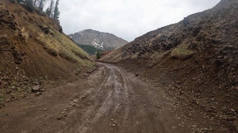
The plan was to take the TAT backward from Lake City to Trinidad. I took off for the climb to 10k out of Lake City and right around where the Cinnamon Pass entrance is it started raining. I’d checked the weather at the coffee shop, and it said an hour’s worth of drizzle, so I was geared up and ready for it. No big deal. Unfortunately, the rain didn’t stop the rest of the day. It only poured a couple of times - mostly it was just a misty light constant drizzle. And it got extremely cold as I climbed. I regretted the shorts. It got down to 40 degrees at elevation. Not the best setting for motorcycle riding.
Even in the rain though, the descent was gorgeous. Unfortunately, I had to put the cameras away because the mist would surely mess up the GoPro Media Mod that handle's the audio (it’s happened several times) - but trust me. Canyons and rushing rivers and there were views for sure - I just couldn’t see them.
By the time I made it to Tomichi Creek Trading Post in Sargents, I was chilled to the bone and my gloves were soaking wet. The rest of me was dry though - my rain gear works well. I parked the bike, went inside, and started drinking a bottomless cup of coffee that the waitress would not let end while commiserating with Johnny Pow about what my plan should be. Had I been able to do the Owl’s Creek Pass, I would have arrived here to camp for the night at the right time. That was the plan. But I was there at 11:15 am and wasn’t anywhere near ready to stop riding after only six hours. I sat there for an hour and a half and things started to clear up. The radar still didn’t look great, but - let’s just go for it. Marshal Pass was next. I headed up.
It was nice and clear for a while, and then the rain started again, and it didn’t stop. Nothing terrible, just a constant mist. I’d found a GoPro door so at least I could shoot some stuff with one camera.
Marshal Pass is easy - we did it in the opposite direction on the TAT. It’s just a long dirt road to the top and back down. But there’s one optional part called Poncha Creek Road that we missed on that trip. Johnny Pow and TAT Steve did it on their Continental Divide ride and said it was extremely challenging and fun. It was on my list to tackle. Pow suggested not to do it in the rain at my last stop, and I wasn’t going to. I’m too close to the end of the trip for anything to go sideways. But still, a final challenge would be nice. I had a waypoint in my GPS that was marked “Decide Here!” I started to hit a bit of mud which leaned things further toward a no.
I decided wet, slippery baby head rocks and crawling through creek beds for miles wasn’t for me at this moment. Another time, maybe. I stopped and took a photo of my bike at the spot where I’d taken one of the little Honda in 2021.
There’s a campground next to that lake that we camped at on the TAT ride. I went down to it, but it was full and it was still too early. I rode through Salida knowing I couldn’t afford to stay there. It’s an expensive place under normal circumstances, but I found out at a gas stop that there is a massive white water festival happening this weekend and everything is full or crazy expensive. The Best Western was $300/night. I headed down 50 to see what I could find. A few campgrounds were full, and at one point I considered slabbing it to Trinidad. I could be there in 3 hours if I took the paved roads. If I stay on the trail it will take 9. Then I came across a rickety motel right on the river that would be perfect.
I got to the motel at about 3 pm and was like - wow - so early. But then I remembered that I’d started at 5 am which made it an 11 hour day.
I got a snack and a couple of beers at the little restaurant next door which was much nicer on the inside than it was on the outside. This is a great last night of the trip.
Tomorrow, I’ll take Sam’s TAT track into Trinidad to end a trip that I thought would be a bit longer. As much as I use these trips to get inside my own head and be by myself - I also realize that wanting to go home and missing my family and wanting to hang out with my wife are good byproducts too. There’s a danger of getting too used to your day-to-day, not realizing what you’ve got, not appreciating who you’ve got, and entering a routine where you can’t even see what you’re doing because you’re so deeply inside it. A trip like this can help give you a zoomed-out perspective where you can see how everything fits together a little better.
Hopefully, the truck is still there. I’ll probably stay at the same fleabag I stayed at coming out, get some rest, load up the bike, and head for home the next morning.
“Upon us all, a little rain must fall…” Was that Billy Shakespeare or Bobby Plant? Is there really much of a difference?
NOTE: I’m on the road typing in less-than-ideal circumstances, so spelling and grammar no longer count. If I don’t post it’s because I don’t have service. I know you’re all waiting with giddy anticipation… To watch all of this on video when they post - subscribe to the YouTube channel.
The store in Cotopaxi, where the TAT. turns off of 50, seRves a good breakfast. I'd guess you are at the rocky top river Ranch. I haven't stayed there, but I've stayed down the road at Bighorn CG. Are you going by Bishop's Castle? It is a must do if you haven't seen it before.


The store in Cotopaxi, where the TAT. turns off of 50, seRves a good breakfast. I'd guess you are at the rocky top river Ranch. I haven't stayed there, but I've stayed down the road at Bighorn CG. Are you going by Bishop's Castle? It is a must do if you haven't seen it before.
What's next? I got some ideas. https://advrider.com/f/threads/gcbar-grand-canyon-backcountry-adventure-route-the-complete-route.1121875/